Schools and Rec 1968
Okay, not as exciting as the segregation map, but this is of the neighborhood. The actual map is bigger but there is only so much that will fit on a photocopy machine or scanner, so deal. This is a National Capital Planning Commission map from 1968. Please take care to look at where Bundy is. That shading that is on its western and northern sides is recreational land. The land the school building sits on is school land.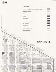
I also uploaded some maps of the elementary, ,junior high, and senior high school borders in Shaw in 1968 on to Flickr. Just look in my DC maps set.
Labels: neighborhood history
posted by Mari @ 17.9.09
![]()
![]()


3 Comments:
so, using this as parking space is taking away from what was "traditionally" recreation space in the community, right?
(i know i'm oversimplifying, but that's all that a lot of the people in this debate have been doing for months, so i figured i'd just jump into the deep end of the pool with them...)
As I understand it a portion will be used for parking and what is left is enough for a dog park. HOWEVER, the land hasn't been transferred over from the feds to the city. But that hasn't stop things from parking and sitting on that portion of the property.
How's this for oversimplification: "We got robbed."?
The site really isn't that big if you walk over and take a look and compare it to the often overcrowded temporary Shaw Field dog park (aka: "Pebble Beach").
Hundreds of dog owners. Few seem to care now. They'll be complaining after the deal is done and it's too late to do anything to change it.
The land transfer is not happening any time soon. There's still time for residents to speak up, engage the Mayor and Councilmembers to give the community what it needs.
Thanks for getting this info posted.
Post a Comment
Links to this post:
Create a Link
<< Home