Truxton Circle- People and a lost traffic circle
If you haven't seen it arleady
Left for LeDroit has a post on the Truxton Circle and how you can still find it's outline today.
And I think I can say I can now start the writing portion of Truxton Circle 1900. I cleaned up a lot of data, deleted addresses that you'd think were in the study area, but aren't and tracked down people for whom some enumerators were too drunk to write down their addresses. When I started out whites outnumbered black residents by a smidgen. With the data clean-up and address removal, blacks outnumber whites by a smidgen and I still have 4 Chinese guys.
There was this one fellow, Paul Pearson, of 218 N Street. He was a white DC born Druggist, who lived with his Maryland born wife, Emma, and owned his home free and clear. According to the 1899 city directory he worked at 500 New Jersey Avenue NW. The National Association of Realtors building sits where his workplace sat. Considering where his home and work were located he must of had a pretty good commute. And if memory serves me right there was a streetcar nearby that could have taken him straight there.
Labels: data/demographics, neighborhood history, Truxton Circle


National Homeopathic Hospital

At the corner of 2nd (Kirby) and N Street NW.
Labels: neighborhood history
What should I do with this data
Because my study area of Truxton Circle for the 1900 census (actually all of the censuses) has angles and odd streets, my cousin will capture data for houses outside the study area. For example I have some of the 300 block of M Street, which is in Mount Vernon Square. Also parts of the even side of New Jersey Avenue, the 1100 block of 3rd, and a few odd houses that happen to fall outside the study area.
So what should I do with these bits of info? I won't be factoring them into my study, but I would hate to just delete them. Any suggestions?
Labels: neighborhood history
More census data- ED 104 year 1900
Don't say the unemployed have nothing to do. My cousin whom I have tasked to give me census data in exchange for room, board, and a mictroscopic stipend is getting pressure from her unpaid internship and parents to do other stuff. But regardless I got more data, this time enumeration district 104 which covers North Capitol, parts of 1st, the alley behind 1st (so distictive it doesn't even get a real name) unit blocks of Hanover, Bates, Q, O, and P. Here is just a taste of what I got:
46 Bates St Kraft, Annie Head White Female (born)Jul 1861 38yo Widowed (born)Maryland Ireland(parent) Ireland(parent) ???(occupation) Rented
She lived with her twin daughters aged 18, Emily & Katryn, who were hairdressers, 16 yr old daughter Mabel a saleswoman, 15 year old son Albert, a salesman for a grocery store, and 14 year old daughter Ida who was still in school. They shared 46 Bates with another family consisting of 4 people.
I still have yet to do quality control for ED 64, but it looks like I might be done with 1900 by mid January.
Labels: neighborhood history
The past is a weird country you only get to visit via travelogues
I was chatting with my cousin about the census project. We were on the topic of occupations. Some bewilder her, like hustler and huckster and compositor. Then there are others where she was amazed at the sheer number of laundresses. Lota lota laundresses. Off the top of my head I was trying to remember the
history of Washington DC domestic service, along with the history of American consumer culture and the rise of the home washing machine and indoor plumbing, which would have made a laundress unnecessary. Later, conditions changed where the "need" & "supply" for domestic servants (another large female occupation) disappeared.
She also noted the large number of people in one house, also unusual for our time, normal for then. I explained that several houses in the neighborhood were two or more units. You can see it with some of the Bates Street houses still, where there are two doors, one for the lower unit, and another for the 2nd floor unit. Regardless, there would be three generations sharing a house or a unit.
Another shocking thing I told her, not revealed in the data, but coming from the whole laundress and plumber (a biggy for white males) discussion, was the lack of running water in many neighborhood houses. Yes, not every house had running water inside. Think of all the things you use that requiring water on command (toilets, dishwasher, shower, etc) and imagine not having that. I illustrate this for her I recalled one of our late grandmother's odd habits such as keeping a chamber pot under her bed. She had running water, but she was, eh, mentally ru-ral. The running water problem lasted up till about the late 50s or 60s in parts of Shaw.
Labels: history, neighborhood history
Renting and owning in the upper TC 1900 style
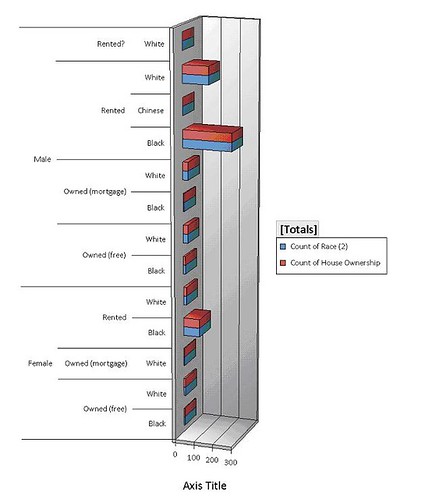
This is the one chart I've managed how to figure out to do. I could go through the training course to figure out Access 2007, but right now I'm going to fool around with it and hope for the best. So in fooling around with the data I present the above. It is the level of ownership and renting for blacks, whites and one Chinese guy, divided by gender. Just going by heads of households, blacks outnumbered whites in the northern (1st, O St, NJ, FL & RI Aves) portion of the Truxton Circle study area, and most households rented. There were two types of ownership shown here, mortgage and free. Free, meaning free and clear, meaning no mortgage and the heads owned the house outright.
Now given that most housing is rental housing it would stand to take it that people where a bit mobile, as renting a house doesn't tie one to a place for any longer than the lease. It will be interesting to see if I can get to the 1910 census how many people remained in the same spot for 10 years or more. I'm gonna bet very few, less than 5-10%. Looking through I know that at some point there is a large influx of North Carolina and South Carolina Afro-Americans who show up in later censuses, so far I see a lot of District natives, and people from Maryland and Virginia. And just as a note, so far no Italian borns, I'm guessing all those Italians who were
around to support the Catania were living in an enumeration district we haven't gotten to, or had not arrived. Well when I get the eastern TC data I'll play with that too.
Labels: housing, neighborhood history
SQUEEEE!!!! Census data
Ah, the best use of an unemployed college graduate and a spare room. I hired my cousin to do some data entry on the 1900 census and she has just completed enumeration district 64, which is the northern part of the TC. Enumeration District 64 (ED64)goes from the 1400 block (odd #) of NJ to the 1700 block, Florida and Rhode Island Aves, 1st St, to Q and O Streets. I immediately tossed the Excel worksheet into an Access database and created a query about working women. Now I'm still getting used to the updated MS Access program and can't seem to figure out how to exclude women "at school". Women over the age of 15, 595 of them had some occupation. Of those 595 women, 473 were black. In 1900 the TC north African American women were laundresses, nurses (child and sick), house servants, and cooks. White working women were saleswomen, teachers, house keepers, landladies, office workers, and seamstresses.
Disclaimer-
To clarify, my census project is sponsored personally by me. I get moral and other minimal support from my employer, as it sort of falls under professional development. Secondly, this is NOT a building or house history project. Things like houses are secondary, people are more interesting. I have no intention of putting the raw data on-line. For one, it's too much. ED 64 is over 2,500 names alone, and there are 3 other EDs to go. I do hope to go on to census years 1910-1930. However the rate we're going I'll probably get through to 1910 or 1920.
Labels: data/demographics, neighborhood history, Truxton Circle
Anyone wanna take bets on the WD/Shaw Library Windows?
If you walk or ride by the corner of Rhode Island and 7th you'll see the skeleton of the Waltha Daniels Library going up. When it is all done it will be all modern looking with glass sides. But here's the thing, we've had an unfortunate spate of shootings near the Shaw/ Howard University metro entrance, including one incident yesterday. Worse yet those last few shootings occurred around rush hour. What is this? Are the shooters getting off work or school thinking, "3:30 leave. 4:00 shoot at Quay-Quay. 4:05 run over to the 7-11 and pick up a Coke and some Ding Dongs." So you mix people with questionable aim, guns and a glass library. I'm sure the library designers are putting in bullet-proof/ shatter-proof glass, but even still.
Guess the problems that used to be at Kelsey Gardens have mosied on down to Lincoln-Westmoreland. Lincoln-Westmoreland had problems on its own before, but was just one of several problem spots up and down 7th Street.
Lincoln-Westmoreland was one of those church sponsored housing buildings that went up in the early 70s. It is named for the two churches involved, the Westmoreland Congregational Church (white) and the Lincoln Memorial Congregational Temple (black), both could be described as being predominately middle class. Apparently these were built to fight poverty. Though it concentrates poverty (a popular thing to do back then) it does provide housing. I should say the Feds chipped in money into the building and was completed in 1971.
Labels: crime, neighborhood history
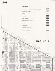
Schools and Rec 1968
Okay, not as exciting as the segregation map, but this is of the neighborhood. The actual map is bigger but there is only so much that will fit on a photocopy machine or scanner, so deal. This is a National Capital Planning Commission map from 1968. Please take care to look at where Bundy is. That shading that is on its western and northern sides is recreational land. The land the school building sits on is school land.
I also uploaded some maps of the elementary, ,junior high, and senior high school borders in Shaw in 1968 on to Flickr. Just look in my DC maps set.
Labels: neighborhood history
1236 New Jersey Ave NW, late 19th century
I found something today and I'm all excited. There was a Navy file where the applicant threw in his home address, though it wasn't required....
Albert W. Evans lived at 1236 New Jersey Avenue in 1898 with his wife and child, applied to become a Hospital Apprentice First Class in late 1898 at the age of 26. He was born in Alexandria, VA. Wore glasses (according to other paperwork in his file) and had not so great vision even with them. Of his education he wrote that he went to, "the public High School, and was graduated in Medicine in 1894, from the National Medical College [in] this city."
He was applying to the position because he wrote that the money he was getting in his then current wasn't enough to support a family.
38-P9-Bx1
Labels: neighborhood history
From the Pile: Bundy School & Park
The pile knows all, and the pile is very, very disorganized and headed for the recycle bin. I find stuff of interest and it goes into the pile.
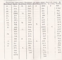
Here's something from the pile, a 1968 report on public facilities. The most interesting stuff is about DC medical clinics in Shaw that are no more. Not counted are non-DC government clinic such as Children's Hospital (still over in northern Shaw). Anyway amongst that stuff is a listing of DC government land and US Government land in Shaw.
I'm going to cut to the chase, in 1968 Bundy Elementary School and Bundy Playground were understood to be two separate things. When I heard the Director at the meeting mention the post Home Rule land confusion something didn't sound right. It's an understandable error, and so I don't fault the Director on this, and you can say it is all up to interpretation or it doesn't matter. And even the report I'm looking at seems a little confused at times about the Bundy Playground, which on the map includes the lot were the soccer players play and the vacant lot proposed as the 1968 playground. On several pages it says the 2.40 acre Bundy Playground is owned by the US government and operated by the Recreation Department, but on one page says it is owned by the Recreation Department. A paragraph about Bundy Playground reads, "This property contains 104,595 sq. ft. owned by the U.S. Government, but under the control of the D.C. Recreation Department. The playground contains a multi-purpose playing field, 2 basketball courts and elementary apparatus for small children."
Of course, this is just a snap shot from 1968. Heavens only knows what understandings, change of responsibilities, etc occurred with Home Rule in 1973 (just 5 years later) or disorganized administrations.
Labels: city services, development, neighborhood history
Will do history for food/ keyboard
Here's the thing. I need a new
keyboard for the old Mac. The current one is kinda cruddy and it would be a simple task to ride on over to the Apple store in Arlington, but I've noticed that I haven't been across the bridge to Virginia for what seems like a year. And thus, I have discovered this personal record of not going somewhere and would like to extend it to Thanksgiving (I may want to hit up Pentagon City for Christmas).
So what is this to you? Well if you live in Truxton Circle or one block off on the New Jersey side or the New York Avenue side, I will do an address history for you in exchange for a new keyboard. Since I have a lot of data related to the constantly dropped Census project and can hit 3 repositories for DC history on my way walking home, it would be a sort of easy for me. My qualifications? Seriously, if you need to know, is a MA in Early Modern European History from UMASS-Amherst and an MLS (grad degree in Library Science) from UMCP and over 10 years working in libraries and archives. So this is a deal.
But you'll get what you exchange for, meaning I'll give about 5-10 hours of work and no more than $10 worth of photocopies. Also no packaging, just raw data. I like to leave interpretation up to the user.
So, who wants to get me a keyboard?
Labels: neighborhood history
Truxton Circle in Shaw
Shaw and Truxton as a conceptMaps from the mid 19th century do
show some settlement in the area presently known as Shaw[1]. But the structures are clustered along a few main roads while other areas, like modern day Truxton Circle, are empty with a few isolated lonely structures.
As time progressed the population of the area grew. However, there is little to no evidence of any particular neighborhood name such as Shaw existing prior to the urban renewal project in the mid 20th century. Despite a circle there is no evidence of Truxton Circle as a neighborhood name, rather it was a landmark that things were "near" [2].
Prior to the Federal government's National Capital Planning Commission, along with the RLA (Redevelopment Land Agency), creation of the Shaw School Urban Renewal Area, the name Shaw was associated with the Jr. High. It's application to any particular area could be stretched with the application of that
school's borders which was established in the 50's [3]. As part of the Redevelopment Act (of 1961?) the National Capitol Planning Commission
defined the borders of what is modern Shaw as the Shaw School Urban Renewal Area. See
this map from 1970 to see what was and what wasn't Shaw [4].
Truxton in ShawIn 1969, a grad student working with MICCO, Model Inner City Community Organization, in Shaw, noticed, "Concentrations and/or differences in land uses, physical conditions and building types, income property ownership and race coupled with identifiable places of community activity, all combine to suggest several communities within the Shaw area (see map 3)." One of the communities Mr. Reginald Wilbert Griffith mapped out in his MIT dissertation, fits the outline of Truxton Circle [5]. Also another smaller community within Shaw acknowledged it was in Shaw. In 1973 in a report submitted to RLA in the introduction, the first sentence reads, " The Logan Circle Historic District is a unique assemblage of 154 Victorian buildings located in the Shaw School Urban Renewal Area"[6].
Unfortunately Truxton is separated from the rest of Shaw by Ward boundaries. The majority of Shaw is in Ward 2, while Truxton is in Ward 5. These political boundaries also reflect police districts, most of Shaw being in the 3rd district and Truxton in the 5th. So with these political boundaries, determined by census data, like congressional districts, it may give the false appearance that Truxton is it's own separated neighborhood.
Okay, I'm not really interested in adding anymore footnotes, so I'm stopping. Disagreeing commenters can talk about their feelings and opinions which are neither evidence nor proof. In the arguments about borders and such it seems no one bothers doing research. Claims with out anything to back it up is just bull.
Messy Footnotes-1. Map of Washington City, District of Columbia, seat of the federal government : respectfully dedicated to the Senate and the House of Representatives of the United States of North America / surveyed and published by A. Boschke C.E. from the Library of Congress. Circa 1857.
2.
SALE OF SIX HOMES SHOW PRICES HIGH The Washington Post (1877-1954). Washington, D.C.: Apr 27, 1919. p. R6 (1 page) and
$110,500 IN SALES OF HOMES IN CITY; Houses Fetch $17,500 Disposed by Hartung & Gibbons. The Washington Post (1877-1954). Washington, D.C.: Nov 7, 1920. p. 34 (1 page).
3. "Corning Sets Integrated School Zone Boundaries," by Marie Smith, Washington Post, July 2, 1954 p. 1, 25-26.
4. NCPC File No. UR-07 "Resolution Modifying the Boundaries and Urban Renewal Plan for the Shaw School Urban Renewal Area"; File UR 07 Modification #6 NDP 2; Records Relating to Urban Renewal; National Capital Planning Commission (1952-), Record Group 328; National Archives Building Washington, DC: and SHAW SCHOOL URBAN RENEWAL AREA District of Columbia. As adopted by the National Capitol Planning commission and approved by the District of Columbia Council through March 29, 1973. N.C.P.C Map File 31 20
5. "
The influence of meaningful citizen participation on the urban renewal process and the renewal of the inner-city's black community: a case study - Washington, D.C.'s Shaw School urban renewal area - MICCO, a unique experiment." by Reginald Wilbert Griffith 1969. MIT, Cambridge, MA
6. "The Logan Circle Historic Preservation Area: Summary if a Report Submitted to the RLA" by Turner Associates, P.C. and Nicholas Satterlee & Associates. Summary prepared October 1973. (Possibly from the National Archives RG 328, National Capital Planning Commission, unknown series, box 92, no file.)
Labels: neighborhood history, SSURA, Truxton Circle
Crap Today Must Be Truxton Circle Day
Prince of Petworth has
"Reader Finds Remnants of Truxton Circle."and though posted yesterday, but the
comments are from today...
BACA Blog asks
What's in a Name? particularly the name Truxton Circle.
And during my lunch hour I created this bibliography thing about the TC and the WP. Click comment to see it all.
History of the term “Truxton Circle” in the Washington Post
[Method search “Truxton Circle” in ProQuest looking for articles only prior to 01/01/1940 in the Washington Post, which includes the Washington Star. Not all articles are cited.]
THE DISTRICT SURVEYOR.; Recommendations About the Preservation of Plats and Records. The Washington Post (1877-1954). Washington, D.C.: Aug 1, 1891. p. 5 (1 page)- regarding surveys for proposed circles. This is the earliest mention of the TC found.
ASKS DISTRICT TO PAY; Dog Catchers Caused Injury to a Bicycle. CHASED BULLDOG, BROKE A WHEEL Animal in Attempting to Escape the Net Ran Into the Bicycle of P.J. Nee, Who Claims Damages -- District Auditor Approved Application and Recommends Payment -- Plants from Mount Vernon Square to Decorate Other Reservations. The Washington Post. Mar 15, 1900. p. 12 (1 page) – Shrubbery for the circle. No mention of the Knights who say shrubbery.
AFFAIRS OF ECKINGTON.; Mr. Macfarland Opposed to Citizens' Associations' Candidate for School Board. The Washington Post (1877-1954). Washington, D.C.: Jun 26, 1900. p. 2 (1 page)- Mentions moving a fountain at Pennsylvania, M and 26th to “Truxton Circle in Eckington.” Citizens associations tended to be white, and the Eckington Citizen Association I’ve noticed stuck their noses in the affairs of things south of Florida Avenue to about New York Avenue. Prior to 1900 the TC wasn’t heavily populated, in 1880 there were less than 1,000 persons living in the area.
MR. MACFARLAND THEIR GUEST.; Commends Interest of Citizens' Association in Public Affairs. The Washington Post (1877-1954). Washington, D.C.: May 28, 1901. p. 8 (1 page)- Mentions the Eckington and North Capitol Citizen Associations, and them thanking the city for the fountain at Truxton Circle.
SALE OF SIX HOMES SHOW PRICES HIGH The Washington Post (1877-1954). Washington, D.C.: Apr 27, 1919. p. R6 (1 page)- 51 Q Street NE (modern Eckington) being described as near Truxton Circle. In same article Dupont Circle is described as a neighborhood. TC not described as such.
$110,500 IN SALES OF HOMES IN CITY; Houses Fetch $17,500 Disposed by Hartung & Gibbons. The Washington Post (1877-1954). Washington, D.C.: Nov 7, 1920. p. 34 (1 page). 149 Bates Street sold and described as being near North Capitol and Truxton Circle. In same article, Bloomingdale described as ‘an attractive area’.
RYAN QUITS CENTRAL CITIZENS' PRESIDENCY; Will Head Movement to Form Another Association in Same Territory. SECTION CALLED TOO BIG The Washington Post (1877-1954). Washington, D.C.: Apr 26, 1925. p. 2 (1 page)- Mr. Francis J. Ryan proposes a new citizens association that would have borders from NY Ave, Truxton Circle, and New Jersey Avenue……
AUTO SIGNAL LIGHTS TO BE READY DEC. 15; Sixteenth Street Crossings and Truxton Circle to Be Equipped. The Washington Post (1877-1954). Washington, D.C.: Nov 14, 1925. p. 20 (1 page)- Truxton Circle gets a traffic light.
Girl Drives with Arm Around Poodle; Fined. The Washington Post (1877-1954). Washington, D.C.: Jul 9, 1926. p. 22 (1 page)- In sub article, people are skinny-dipping in the Truxton Circle fountain.
$15,000 Asked in Suit For Alleged Injury. The Washington Post (1877-1954). Washington, D.C.: Aug 13, 1926. p. 20 (1 page)- Woman Sues streetcar company because of injury in a car at the TC.
NOTES OF DEPARTMENTAL PERSONNEL; News of Departments
The Washington Post (1877-1954). Washington, D.C.: Jun 19, 1927. p. S10 (2 pages)- Mention of Truxton Circle Station Post Office. The post office will out live the circle.
400 CARRIERS NAMED FOR CHRISTMAS MAIL; Postmaster to Appoint Equal Number of Clerks for the Holiday Rush. BARGAIN DAYS ANNOUNCED
The Washington Post (1877-1954). Washington, D.C.: Dec 11, 1927. p. 2 (1 page)- Post office. Other post offices mentioned are U Street and Petworth.
$25,000 Asked for Injuries. The Washington Post (1877-1954). Washington, D.C.: Jul 11, 1928. p. 8 (1 page)- Did they have a phone and if so, did they have a lawyer? Lawsuit regarding traffic accident at Truxton Circle.
Washington's Fountains Temper Summer's Heat; Increased Supply of Water Due to the New Filtration Plant on Conduit Road Enables the City to Keep Fountains Going More Regularly Than in the Past -- Boon to Children and Other Stay-at-Homes. Washington's Fountains Temper Summer Heat, by Victoria Faber Stevenson.. The Washington Post (1877. Jul 29, 1928. p. SM3 (2 pages)- Mentions how the Truxton fountain in Truxton Circle was becoming a landmark.
MAN DIES TWO HURT IN MOTOR MISHAPS; Driver of Truck Is Instantly Killed When Crushed Against Radiator. LAD PAINFULLY INJURED. The Washington Post (1877-1954). Washington, D.C.: Dec 17, 1929. p. 5 (1 page)- First noted traffic death at the circle. The problem was truck was overloaded with granite and crushed driver.
Bandit Pair Robs 2 Filling Stations; First and H and Wisconsin and Q Gasoline Depots Are Victimized. The Washington Post (1877-1954). Washington, D.C.: Dec 27, 1932. p. 14 (1 page)- First noted robbery of Truxton Circle post office at 17 Florida Ave NE.
[article search 1940-1999]
Post Office Bandits Get $500 Here, The Washington Post, Times Herald (1959-1973). Washington, D.C.: Jul 24, 1965. p. A3 (1 page)- Last mention of Truxton Circle post office getting robbed.
Subsidy Program's Nuts and Bolts, The Washington Post (1974-Current file). Washington, D.C.: Aug 2, 1984. p. A15 (1 page)- Truxton Circle first mentioned as a neighborhood as a target area for mortgage subsidies.
D.C. Cable Firm Unveils Wiring Schedule, Seeks More Concessions; D.C. Cable Firm Tells 5-Year Plan, Seeks Concessions , by Marcia Slacum Greene Washington Post Staff Writer. The Washington Post (1974-Current file). Washington, D.C.: Sep 4, 1985. p. C1 (2 pages)- Another article mention of Truxton Circle in listing of neighborhoods to get cable.
Community Outcry Wins Reprieve for Lenny's; Bank Delays Evicting Popular Neighborhood Store Until Buyer for Building Is Found by Elizabeth Wiener Special to The Washington Post. The Washington Post (1974-Current file). Oct 31, 1991. p. DC2 (1 page)- Quote” I understand the position Riggs [National Bank] is in – they just want to download the property, and they’re within their rights, “ said Kathy Glynn, chairman of the Truxton Circle Coalition, an umbrella group for civic associations in the area. “But we’re really getting tired of the constant destabilization of businesses moving out because of crime and real estate turnovers. This is a store people rely on.”Labels: Bloomingdale/Eckington, neighborhood history, Truxton Circle
Random Alley History Notes
Last week I wandered over to College Park, to visit the National Archives's Still Picture Records Section. They have a series 302-DC called "Photographs of Low Rent Housing and Housing in Inhabited Alleys in the District of Columbia, complied 1934-1941, documenting the period 1916-1941." No. I have no examples of the pictures because I do not have a copy card for that location and I didn't want to go down and spend the money to get a copy card I'd never use again and wind up losing.
But I took notes. There apparently was another Naylor that wasn't the Naylor Court we know. It was Naylor's Alley on Sq. 515, which is over in Mt. Vernon Triangle as far as I can tell. There are some great pictures there, including a few snaps of a "Woman Evangelist," a black woman in the middle of the alley wearing a coat.
Over on Sq. 512 which is between N, O, 5, 4, and NJ, was Kings Court where there are several pages of photographs.
For some odd reason I have a note about a picture of a toilet on Langston Terrace, which I think is somewhere in SW or SE.
Something I really should have gotten a copy of is a photograph from 1916 of the
Mulumba House at 621 Rhode Island Avenue NW.
Labels: neighborhood history
The Lost Alleys of Shaw- and some other places
I've got a whole bunch of photocopies of DC alley related history, circa 1930-1940ish. All of it disorganized, which is my fault. Anyway, armed with my pre-20th century map of Shaw east of 9th St, with all the block squares numbered, I will search for alleys long gone.
Sq. 447- Freeman Place (N, O, 6th, 7th Sts NW)
Sq. 448- Madison Alley (M, N, 6th, 7th Sts NW)- Mt Vernon Sq
Sq. 449- Congress Court (L, M, 6th, 7th Sts NW)- Mt Vernon Sq
Sq. 512- Kings Court (N, O, 4th & 5th Sts NW)
Sq. 514- Browns Court (M, NY Ave, 4th & 5th Sts NW)- Mt Vernon Sq.
On a photocopied list titled "Alleys to be studied for demolition since 1934" a few things pop out.[]-are mine
Sq. 1189 [Georgetown];Copper Shop Alley; House No. 3136 (31, Wis, Water, South NW)
Sq. 1205 [Georgetown]; Bank Street; House No. 1218-20 (33,34,M, Prospect NW)
Sq. 513 [MVSQ]; Ridge St. Court; House No. 440&438 (4,5,M,N NW)
Sq. 419 [Shaw]; Wynns Ct.; House No. 1711, 1709, & 1707 (7,8,R,S NW)
Sq. 367 [MVSQ]; Nailors Alley; House No. 1324-1326 1/2 (9,10,N,O NW)
Sq. 340 [?]; Durrs Court; House No. 1248 (10,11,M,N NW)
Sq. 302 [Shaw?]; Davis Court; House No. 2-5 (11,12,W, Fla)
Sq. 276 [Shaw]; Quaker Court; House No. 1210 (12,13,R, S NW)
Sq. 205 [Shaw]; Waverly Terrace; House No. 1922-26 (14,15,T,U NW)
Labels: neighborhood history
SSURA history
SSURA-Shaw Urban Renewal Area
I've been tearing up the house trying to find an eyeglass perscription among the piles of paper that litter my house. One of the piles was 'neighborhood history that I'll blog about at some point'. As I wait for a bunch of podcasts to download, I'll type out this find. It is a transcript from the National Capital Planning Commission's Executive session March 3, 1966, starting around page 42:
Chairman Rowe
Now we get to this review, Mr. Conrad, of the proposed urban renewal area in the Second Precinct around the Shaw School. Would you give us the background.
(Mr. Roberts departed the meeting at 4:55 o'clock p.m.)
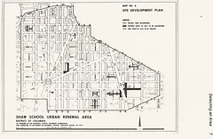
ITEM NO. 4- SHAW SCHOOL URBAN RENEWAL AREA
MR. CONRAD: In 1958 the staff prepared a general neighborhood renewal plan in the Second Precinct area which is about the same area as you see encompassed by the red line on the map on the board which was 14th Street to the west, Florida Avenue to the north, North Capitol Street to the east and then down to Massachusetts Avenue and 10th Street on the south.
This is a rather large area. It contains about, oh, I believe nine to 12 projects that were supposed to be done over a period of ten years but were very limited when we went into the study of this area.
We were limited because of the housing tools that were available at that time. We were also restricted because of the high cost of rehabilitation and no write down to the process of urban renewal at that time. We were also restricted because there was very little citizen interest in this area.
As a result the large area was cut down to what the Commission knows as Northwest Number One which is about a 76-acre project which we have approved and which the Redevelopment Land Agency now is carrying out.
Since 1958 there have been quite a few changes. It is possible to get write down on rehabilitation. There is the 221-d-3 moderate cost housing, relocation housing. There are new forms of public housing which we have. The President is coming up with a demonstration city where we should get larger areas in order to be able to stage the development. Also the Shaw School has come into its own as a need and the President has also pointed out the examples where we should take schools and make them examples for other cities and this is a wonderful location to do it.
So last week Mrs. Rowe, three District Commissioners, Walter Washington, the staff and also some citizens from this area got together and now the citizens are asking for public help to do something with their area.
Reverend Fauntroy was there representing the area as well as Mr. and Mrs. -- was that Lawson?
CHAIRMAN ROWE: Judge Lawson.
MR. CONRAD: Judge Lawson. They feel that the citizens are ready for this and they are looking for help from the proper public bodies.
We are working with D.C. on this as well as the Redevelopment Land Agency and we propose to come back to the Commission at its next meeting in April with specific boundary lines for approval so that we can go in for planning advances to at least study this area for urban renewal.
There is more but this was long enough and the keys on my keyboard get kind of sticky.
Labels: neighborhood history, SSURA
Age of a neighborhood
Reading through the digest versions of the MVSQ listserv* I noticed an announcement by Alex Padro for
an event today at the Historical Society. Yet in his introduction, "Come explore the changing streetscape of one of Washington's oldest neighborhoods..." bugged me. How old is Shaw? With some other neighborhoods the age is a no brainer. LeDroit Park and Eckington were built by developers and you just track the date down to the developer. Georgetown, was a town, with a town government.
With Shaw, there were houses and people in the area prior to the Civil War. But so far in my own dabblings I haven't seen any reference to the area as 'Shaw' until the mid 20th Century. And the earliest was at best the boundaries for Shaw Jr. High, never mind the elementary schools and the high schools. Trying to tie it down by civic/citizen associations haven't been helpful. Back when the ECCA (East Central Civic Association), played a real role in city life, it's boundaries were all over the the place. But regardless, it did include great parts of present day Shaw east of 7th, as well as the Sursum Corda area, and eastern Mt Vernon Sq., and it's an early 20th Century thing.**
So, how old is this neighborhood? How is that age determined and what is it based on?
*Believe me you'll find listservs more manageable and keep your sanity by getting some discussion lists in one daily email.
**"East Central Civic Group Seeks Vote :Improved Housing, Clean Block Drive Also on Program." The Washington Post,p. 17. 12/7/1940.
Labels: neighborhood history, SSURA
Milk, not the movie
I love Ebay, mainly because it is where I get a lot of clothes. It also has some other things relating to local history. Friends of mine who were involved with
Save Our Seminary mentioned that they got some seminary related items off Ebay, which at times would put them in contact with people who had some sort of connection with the long closed girl's school.
Looking on line for information for Embassy Dairy, a milk distributor that was at 1620 First Street NW, I found milk bottle collectors
selling milk bottles from the dairy. It seems the place went by a couple of names. Fairfax Dairy was one name associated with that address, Green Meadows Dairy, was another.
Looking through Pro-Quest the dairy's drivers had a bad habit of hitting local residents with their trucks. So that is one thing that makes me think that this workplace and industrial property wasn't the greatest neighbor.
Currently, the Northwest Co-op sits on the block where the dairy existed.
Labels: neighborhood history
Rambling post

Well there is a BACA (Bates Area Civic Association) meeting tonight, same place, same time. Mt. Sinai Baptist basement, 7pm.
As far as the slum history goes, right now I don't have much to piece together to make a decent or readable post. I am still making notes in
The History and Development of the Housing Movement in the City of Washington, D.C. which describes the company that built the houses along Bates, Q, and 3rd Streets, NW. I was looking to explore something I read on modern 3rd world slums and cottage industries that form from them. However, my big source, The Washington Post of the mid 20th century, focuses on the illegal gill joints and sex trade industries. So I guess I'm not going to explore that.
In the meanwhile, here's a picture of the corner of 3rd and P. Compare with old picture of 3rd and P.
Labels: BACA, neighborhood history
Not a charity but capitalist enterprise
When
last I left I was writing about the Washington Sanitary Improvement Company (WSIC) which built the houses along Bates Street NW, and some other streets in the TC that are somewhat Bates adjacent, around the turn of the century. You know they are built by the same company because their 2nd story bay window thing.
Anyway, the WSIC's goal was to replace the slum dwellings in the various alleys, but as a profitable company and not a charity. From
The History and Development of the Housing Movement in the City of Washington, D.C. page 61, Article III, section 4:
The company, although organized from philanthropic motives, is not a charity organization, and the executive committee shall take all legal measures to collect rents and to evict tenants who fail to pay their rent, or who neglect to keep the tenements occupied by them in a cleanly and sanitary condition, or who lead a dissolute or criminal life.
Another thing, as part of the pitch to draw interest in the company the author and secretary of the company George M. Kobr writes:
The attention of capitalists should be drawn to the fact that no class of realty pays as well as alley property in this city, and that there is a splendid field for investment in the erection of sanitary and comfortable alley houses on a business and humanitarian basis.
--page 23
Labels: neighborhood history
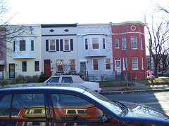
Don't blame me for a fuzzy photo
This was taken with an iphone in a lowly lit room at the Library of Congress from a book, while I held the pages down with one hand and took the pictures with the other. Now why are you looking at a fuzzy photo of a bunch of houses? This is the unit block of Bates Street, when the houses were somewhat new in 1907.
The photo, as well as some others I took are from
The History and Development of the Housing Movement in the City of Washington, D.C. published by the Washington Sanitary Improvement Company, which built the houses. The book starts off talking about unsanitary crappy housing in DC and how the Washington Sanitary Improvement Company (WSIC) was building alternatives to slummy housing, specifically crappy alley housing. Towards the middle of the book they start talking a bit more about the company as an investment. The directors consisted of the following:
David J. BrewerCharles C. ColeJohn W. FosterCharles J. BellGeorge Truesdell
Gardiner G. HubbardAnthony Pollok
Walter WymanHenry F. Blount
Mrs.
George WestinghouseCrosby S. NoyesGeorge H. Harries
William J. BoardmanWilliam C. Woodward
Augustus S. WorthingtonHenry Y. SatterleeGeorge L. Andrews
Bernard T. JanneyMrs. Clara G. Addison
Willliam C. Whittemore
G. Lloyd MagruderJoseph C. Breckinridge
Marcus Baker
Katherine Hosmer
Charles E. Foster
Simon WolfGeorge M. SternbergS. Walter WoodwardGeorge M. KoberJohn Joy EdsonMaybe more later. Or not.
Labels: neighborhood history
Slum dwellers and eco-lifestyle types
As I write this I'll admit I'm have a little trouble putting the idea in my head in any sort of format that makes sense in written form. So bear with me or skip it entirely.Both have things in common. As I look over the early and mid twentieth century Washington Post articles descriptions of life in slums there are some small similarities with the eco-friendly low energy use folks I admire.
The modern American uses a lot of clean water. If you leave the tap going while you brush your teeth, that's probably a gallon going down the drain there. Flushing the toilet, that uses a couple or 3 gallons, more if not everything goes down. And we can do this because of indoor plumbing, wonderful, wonderful indoor plumbing. Tucked away in some eco-media zines and sites are compostable toilets and other contraptions to help reduce water usage. If you don't have indoor plumbing it is a pretty good guess that's you're not going to be using a lot of water if you have to trudge out to a common source to grab it.
Mother gave me a decent description of a rural outhouse's workings. However, I'm still baffled by an urban outhouse, such as the ones in
historical Shaw. Is it hooked up to the sewer system? Is it a regular toilet in essentially a tool shed?
Another aspect of slum life was lack of electricity in some homes and the strong use of kerosene. In an article*, a slum dwelling wood and ice man was lamenting in 1954 how he was going to be put out of a job because people were going to refrigerators. Before you had the
ice box, where you would have a huge block of ice, in a box, to keep food cold. Think of it as a cooler with a door. So not every place was hooked up with enough electricity to support a fridge and I noticed a lot of kerosene usage. Kerosene to light lamps. Kerosene to heat the homes. Kerosene to use for cooking heat. Kerosene is one energy alternative, but seems like a sure way to burn your house down. Wood was still in use as a cooking and heating fuel, as well. Kerosene isn't eco-friendly, like water, if you have to haul it home, and you're probably more conscious of its use.
Wen asking mom about heat she said the house was heated with the stove and at night the stove was off or out, so they bundled up at night. You had several layers and a blanket and a sibling sharing the bed to keep warm.
Why am I trying to tie slum dwellers and eco-living together? Well it was some small similarities such as the low energy and water usage that I kept noticing. However the big difference in that area is that one uses less because of economics and the other uses less because of choice, which then impacts other areas of ones' quality of life. And with the passage of time and enforcement of building codes, indoor plumbing and electricity help, however the other scourges of slum life, crime, poor education, overcrowding, unemployment, remain.
*
No. 2 Leads City in :WASHINGTON'S WICKEDEST, THE SECOND PRECINCT by S.L. Fishbein Post Reporter March 14 1954. The Washington Post.
Labels: neighborhood history, quality of life
Living with no running water
I was doing a bit of background for the blog looking at the series of articles on the "Wickedest Precinct" regarding slum conditions. A big thing that made it slummy, besides the trash, poorly maintained housing, and crime, there was the lack of indoor plumbing and sometimes lack of electricity.
I called up the Great and All Powerful Mom, my mother, since she has a) lived in a house with no indoor plumbing and b) does not turn on the selective memory (like some old folks) to get a better sense of life without running water. Growing up in the country they had a well, from where they got their water from. To bathe they would get a bucket of water, heat it on the stove, and use a bath towel to clean. For the toilet they had an outhouse. I asked about using the toilet. There was the outhouse and at night there was the chamber pot or bucket, which got emptied each morning. Please note how labor intensive things are. Imagine washing clothes and dishes, when everytime you need water, you have to pull it from the well.
I thank G-d for hot showers and flushing toilets. Yes, I understand that a good portion of the world doesn't have those things, which just makes me more appreciative.
But back to Shaw, and details of our slummy history.
In the Washington Post series on the "Wickedest Precinct" in S.L. Fishburn in a March 14, 1954 article "No. 2 Leads City in Vice and Violence" there is a photo showing a woman getting water from an alley spigot. We are told by the caption that it is her only water source. I know from other documentation that it is more than likely true for her and hundreds of other households in the Shaw region in the 50s. There is another photo showing where the outhouse in a sort of lean-to where there is a board to walk on, to walk over the seepage.
Before I close up there is a jewel I want to quote:
The three-story Victorian eclectic mansion at 6th and M sts. nw., which stands out in sharp contrast to the squalor of the alleys behind it, was once the home of banker William Stickney, who served as president of Washington's city council in 1871-74.
Today, with a still-fresh exterior, the mansion houses the church of Bishop C.M. "Daddy" Grace.
His church being the United House of Prayer for All People, UHOP, a presence in the Shaw and Mt. Vernon Sq. neighborhoods.
Labels: neighborhood history
The Wickedest Precinct- #1 in Drunks
In the 50s the Washington Post dubbed the 2nd Police Precinct as the 'Wickedest Precinct'. The 2nd Precinct mostly was what we know as Shaw. It went from K Street NW on the south, the Union Station tracks on the east, Florida Ave NE to North Capitol then S Street NW to the north and 15th St NW to the west.
In "Illegal Liquor Sales An Industry in No. 2 :2d Precinct 1st in Drunks." by S.L. Fishbein (March 17, 1954) The Washington Post p.1 there is a lovely map (sorry I don't have a copy to provide to you) showing where there were illegal liquor sales busts and there is a big ol' splotch of 1953 busts at 5th and Neal Place. I'm trying to think if Neal Place is still there, it's where the Co-ops are now. There's a smaller splotch between S and Rhode Island Ave between what looks to be 6th and 7th St. NW. Somewhere around there was a place called Glicks Alley. Anyone have an idea where that was exactly? Is it the unnamed alley between those modernist Susan Reitag buildings? I can find out in time, but I may as well ask.
The only Shaw mention in the article is the mention of Shaw Jr. High students who had the joy of walking past the drunks in the alley as they cut through to get to school.
There is something about 'gill joints' but I'll write about that later.
Labels: neighborhood history
January 8, 1905
From the Washington Post/ Star under "Social and Personal-- Gay Season Open Until After Inauguration" pg E8[grumble] I bet their streets weren't blocked[/grumble]
Mr. And Mrs. Thomas D. Schnopp entertained a number of friends at their residence, 318 Florida avenue northwest, last Monday evening, the occassion being a New Year's party. During the evening a pleasing programme, consisting of vocal and instrumental solos, were rendered by well known talent. At 10:30 the assembled company repaired to the dining room, where a generous repast was served. The decorations consisted of palms, ferns, and cut flowers, the whole making a pretty effect. Those present were Mr. and Mrs. Frank Ruppert, Miss Florina Ruppert, Mr. John T. Schnopp, Mrs. Ellis, Mr. and Mrs. George Glorius, the Misses Glorius, ...
Longtime readers may realize that the Glorius' didn't have far to walk. Barely 1 block. Also I wonder what kind of one hick town DC was if your little dinner party is getting reported. Today such a gathering would barely be noted as a noise complaint.
___
Speaking of history there is a
newish blog/website about the criminal and quirky DC of the past.
Labels: neighborhood history
Buy a church for your new home
This place has been on the market for a while and I do wish I could find a non MRIS picture, but
1641 4th St NW is up for sale. According to a
1957 study of NorthWest 1 churches, it served as a house church. That's sort of like a storefront church, but instead of a store, worshipers used a house. Up until last year or two years ago, a small sign reading "Faith Temple" was near the door of this house.
A few years ago, I swear there were more of these little house churches around the hood. I remember years ago walking around 1st and Bates and hearing a woman preaching, well saying words loudly in a rhythm similar to preaching. That's gone now. There is a house church on the corner of 3rd and P. The building looks nice and seems to be well kept every time I pass by. I do have a pciture of that.

The Redfin ad for 1641 4th St, the former Faith Temple, says it has the original wood floors and looking at the pictures it looks like it has a lot of original stuff. I can see how the layout can serve a small number of people.
Now that I think of it, I have attended an Eastern Orthodox service in a converted rowhouse in Columbia Heights. While there I was paying more attention to the fact they had chairs, than the normal, non-churchy windows. Depending on the size of the congregation, a house can work for worship purposes and neighbors like it if worship does not require drums, electric bass and amps.
Labels: churches, neighborhood history, real estate
DC Police Districts
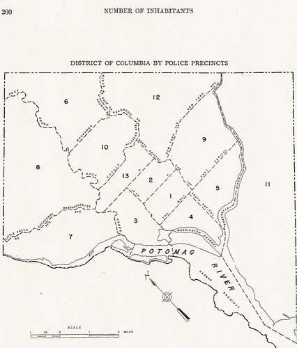
If you can make this map out, it is the police districts for the city, circa 1900-1950-ish. I'm betting 1930. This is once again another sad tale of where I copy stuff and completely fail to note where I got it from exactly.
I know this much, I got it from the Census. The image is sitting on my computer in PDF form and the dates and all sorts of wonderful information would be revealed if I could remember what folder on what drive it sits.
Labels: neighborhood history
DC CensusMap.jpg
I putting this up because occasionally I need to know what census district is which. The dates for this? Your guess is as good as mine. I think it could be 1920, 1940, something like that.
Labels: neighborhood history
If you see me, give me .50c
There is research I can do for free, and nearly free. Following the chatter on the Eckington list about I went to look at the 1929 city directory for eye-talian names. Well, it cost me two quarters to get a sheet copied properly. I'm annoyed, 'cause that's kinda pricey. I'm okay with a dime a copy, .15 cents a copy, but not a quarter a copy, especially when the copier cuts off a lot on the 1st try.
Anyway, I'm not listing all the names, nor am I scanning it anytime soon. But yes, there were Italians on North Capitol, if I go by names. There were some non-Italian names like Charles Quong, laundryman, at 1518 and H. Lee another laundryperson at 1412. But you want Italian examples. Don't you? Ok. At 1410 N. Cap lived Carmelo Puleo, 1420 Venuto Salvatore, and at 1416 Fortunato Figliozzi, a barber. As far as I can tell the other two guys were shiftless unemployed layabouts.
Just as a tad of info if you're looking at the 1930 census Mr. Quong is in the 42nd Enumeration district, page 11B, roll 293. Puleo or Pulis (as listed in 1930 census) is in enumeration district 39, and must have had some employment to take care of those 4 kids of his.
Labels: neighborhood history
Historic KFC closes
We're in danger of losing a bit of Eckington history as one of its businesses has shut it's doors and is possibly in danger of losing some classic late-20th century commercial architecture. The Bulletproof KFC, as one Bloomingdale/Eckington resident once called it, was a testament to a period in the neighborhood's life. It fed many a traveller and resident, overlooking the busy intersection of Florida and North Capitol.
Before this neighborhood landmark was, there was a church, Eckington Presbyterian, that sat there. According to a 1966 article in the Post [1] Eckington Presbyterian "rather than admit Negroes as members, the Church's White congregation disbanded 19 months ago. The 62 year old church building, at Florida Avenue and North Capitol street, has stood vacant ever since and will be torn down soon." Such a pity that a monument to racism was not preserved.
[1]"Clerics Find Prejudice Killed Church" The Washington Post, Times Herald (1959-1973). Washington, D.C.: Oct 31, 1966. p. B4
Labels: Bloomingdale/Eckington, neighborhood history
Billard hall circa 1958

From the
DDOT files showing 9th and Florida Avenue. Traffic looks kinda light.
Labels: neighborhood history, transportation
Oral History
One of the things they teach you in library school (colleges of information studies/science, whatever) is where to find information. You've got your information in books, on-line, other print media and the written word has value. Then there is getting information from people, because really who writes the books, the government reports, the news articles, and the on-line content? People. And when you don't want to flip through a zillion pages of stuff to find the answer, it is sometimes just easier to find an expert and ask them directly.
Yesterday, I hung out with the Davitts, the experts of Bladgen Alley and Naylor Court. I learned a lot, and got a history lesson on late-mid century Washington, DC social and political life. And that history, considering that several of the players then are still alive and involved, is still shaping and coloring the social and political climate of 2008.
I've talked with a number of folks in and around the area. People who grew up around here and left. People who grew up around here and stayed. People who were involved with this or that thing. And I have been told, I need to talk to so-in-so. And as some of the really old timers who are hitting 80 and beyond, or 50 with a bunch of health issues, I know I should try to talk (and better yet interview & record) to, as well as others.
Labels: neighborhood history
Make the ghetto go away, and work together
Of course, we all recognize that if we are ultimately to improve psychological and physical conditions for minorities there must be total elimination of ghettoes and the establishment of a truly integrated society. In the meantime, however, all those working for economic and social justice are forced to address themselves to interim programs which, while not totally changing the situation, will nevertheless bring about improvement in the lives of those forced to live in ghettoes. And so, whiel [sic] many of those steps may lead to limited integration, those which do not must clearly be seen as interim steps until the objective situation makes a more fundamental approach.
and later
... Labor, Housing and the Office of Economic Opportunity, ought to work with the people of Shaw in developing, coordinating and concentrating their various programs upon social and economic problems of this area.
-Dr. Martin Luther King, Jr. speaking at a March 13, 1967 rally for Shaw
Labels: history, neighborhood history
About the past and the present
A lot of my friends are former History majors (or minors) so I sometimes like to ask the question, 'if you could go back in time to any time period what would it be?' The answer varies, depending on their interest. When I add, would you go there knowing you could never come back to the present, then the answer tends to be 'no' from everyone. There is just something about modern medicine and dentistry that makes today a preferred time.
Looking at Shaw's urban renewal history and the 'stuff' that went before, that basically called for the need for the renewal, makes Shaw's past an interesting place to visit but I wouldn't want to live there. Well given a choice between present day Shaw and say the area near the old Shaw Jr. High circa 1940. What I see are a lot of structures built for investment purposes (two or more units on one lot), making it a land of rentals with absentee landlords. Landlords, who if good, did some maintenance and patched here and there, but really weren't very likely to invest in major projects. Overtime that lead to the blighted conditions, which mixed with the crime, and the overcrowding.
The legacy of bad landlords still lives on in Shaw, bringing that glorious bit of history to our present lives. On my block there is a landlord who does very little to keep up the property. This person only cleans out the gutters maybe, maybe, when there is a change in tenants. As these houses are all connected problems from the bad landlord's house, become problems for the adjoining houses. Now imagine 1/2 a block or a whole block of landlords like that.
Urban Renewal Shaw is an interesting place to visit. I like seeing how different community groups came together and split apart. Their visions of the future tells an interesting story of desires and dreams. Their cries of frustration still remain in some corners and in 40 or more years I wonder if somethings can be adequately addressed given that you have mere human beings running things. Now, I wonder if future Shaw might be a better place to stay.
Labels: neighborhood history
When your scanner is limited
The picture is of a legal sized document. Sorta circa 1970 from the same folder as the legalese I wrote yesterday. The problem is my scanner can't get the whole page.
What is this?
"Extremely deficient buildings in Shaw" aka number of crappy buildings that probably need to be torn down. I see Square 513 had 51 crappy buildings. Square 513 is N St, 4th St, M St, and 5th Street. Well considering the post 1970 buildings on that square and the building that committed suicide last (or was it early this year?) year.... yeah. Next on the crap for bricks block is Sq. 617 with 50. That's over with Hanover Pl, and then Sq. 271 with 35 buildings. My little map O'Squares only covers eastern Shaw, so I don't know where that is without doing some more looking.
Labels: neighborhood history, SSURA
April 2, 1970 borders of Shaw
From page 2 from the memo NCPC File No. UR-07 "Resolution Modifying the Boundaries and Urban Renewal Plan for the Shaw School Urban Renewal Area"; File UR 07 Modification #6 NDP 2; Records Relating to Urban Renewal; National Capital Planning Commission (1952-), Record Group 328; National Archives Building Washington, DC:
BE IT RESOLVED, that pursuant to Section 6(b) and 12 of the Redevelopment Act, the Commission adopts modified boundaries for the Project Area described as follows:
Beginning at the southwest corner of the intersection of Fifteenth Street, N.W., and "N" Street, N.W., thence along the south line of "N" Street, N.W., the the southwest corner of Thirteenth Street, N.W., and "N" Street, N.W., thence southerly along the west line of Thirteenth Street, N.W., to the southwest corner of "M" Street, N.W., and Thirteenth Street, N.W., thence along the south line of "M" Street, N.W., to its intersection with the north line of New York Avenue, N.W., to the east line of North Capitol Street, thence along the east line of North Capitol Street to the northeast corner of North Capitol Street and Florida Avenue, N.W., thence along the northeasterly and north lines of Florida Avenue, N.W., to the northeast corner of Florida Avenue, N.W., and Georgia Avenue, N.W., thence along the east line of Georgia Avenue, N.W., to the north line of "V" Street, N.W., extended to the east line of Georgia Avenue, N.W., thence along the north line of "V" Street, N.W., extended to intersect the east line of Florida Avenue, N.W., at Ninth Street, N.W., thence in a northwesterly direction along the east line of Florida Avenue, N.W., to the east line of Sherman Avenue, N.W., thence northernly on the east line of Sherman Avenue, N.W., to its intersection with the north line of Barry Place, N.W., thence westerly on the north line of Barry Place, N.W., to its intersection with the north line of Florida Avenue, N.W., thence along the north line of Florida Avenue, N.W., to the intersection of Florida Avenue, N.W., New Hampshire Avenue, and Fifteenth Street, N.W., to the point of beginning.
Good Lord, that is the most confusing piece of geo-legal-gaaaaah I've ever transcribed.
Labels: neighborhood history, SSURA
Some Make Stuff Up, & Some Bring Proof
I have a laundry list of 1/2 done projects. At work there is the 'paper that should have written itself,' but noticeably didn't. At home there is the 1900-1930 census project, which at the pace I'm going will be done in time for the 1940 census to be rolled out. And way down on the list is correct that damned
Wikipedia page on Shaw. Because I want to actually cite sources, the problem is trying to figure out the coding (which I know shouldn't be that hard) to cite the sources to prove that most of the history written there is a load of horse manure. I'm reminded of this everytime the question of where the borders of Shaw are comes up, like with
DCist .
Maybe I'm too timid when it comes to over writing something that someone else wrote. But then again, I have to ask 'prove it'. The other problem is that I'm a bit shaky and not particularly sure on a comment I wish to make saying that the neighborhood wasn't called Shaw prior to 1950. Okay I actually want to say 1960. However there was a school boundary but as a neighborhood in general I haven't come across any pre-1950 lit saying otherwise. But just because I haven't come across it doesn't mean it such evidence doesn't exist, and that's what concerns me.
So in my mind, the TC is part of Shaw, as it was a federal agency and the DC government that came up with the borders. Yet, people keep doubting and throwing out ideas with no proof or anything to back it up.
Correcting the damned page just moved up again.
Labels: neighborhood history, SSURA
Snippet in Bladgen Alley History
It's in the past, so it counts as history. 1994. Bladgen Alley. Zoning Case ZC 94-14. The idea was to change the zoning for the alley facing buildings from R-4 to C-1 or C-2-A. A look at the current zoning map and the proposed zoning for back then, it appears the effort failed. But what is interesting, and something a researcher (not me, somebody else) may want to explore are the signed petitions, the form and original letters from residents, businesses and workers in and around Bladgen Alley about the conditions of the alley. One interesting piece submitted was a statement, I gather to be read at a Zoning meeting, describing the conditions of the alley as a place of illegal dumping and tranny tricking. There are other zoning cases, in other neighborhoods where testimony is given describing neighborhoods that's just interesting.
I'm sure a more complete story of ZC 94-14 can be found at the DC Archives. The part I encountered is from the National Archives, RG 328 Entry A1-27,
boxes 89 & 90, as an FYI to the National Capital Planning Commission.
Labels: neighborhood history
The remains of the day
I only glanced at the Sunday paper and some other articles relating to the anniversary of the 1968 riots and noticed something. Furniture stores, drug stores, and liquor stores were looted and burned. It seems the only thing to bounce back from the riots quickly were the liquor stores. Correct me if I am wrong, but between 1970 and 2000 wasn't the easiest thing to buy in Shaw was something, anything, that could get you smashed quickly?
When I first moved to Shaw (after bouncing around the metro area), beer and wine, or read 40ozs and MD 20/20, was available every two blocks. Now, sorta yes, sorta no. The Bates market, has been shuttered for a while, but it is no longer selling anything. The liquor store on 4th and Florida is transitioning and sells a selection of wines you can cook with.** G&G on New Jersey sells no alcohol. But there are still several old style liquor stores in the hood with the scratched up Plexiglas and 90-100% of the merchandise behind it.
So 10-20-30 and 40 years after the riots, you still have liquor stores. I can't remember if it was DC or some other post riot city where a black businessman was interviewed. To bring business back to the black community he.... opened a liquor store. I could only shake my head. So though very flammable, liquor is what remains when the fire has died down.
**I don't believe you can cook with Boone's Farm. Actually, I don't think anyone in their right mind should drink Boone's Farm.
Labels: business, neighborhood history
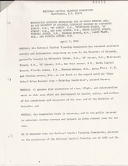
Scanning History
I'm trying to bring some order to my history collection. Somethings I'm holding on to because I wanted to share them with others, like this letter. But knowing that it is the responsibility of the Federal Government to keep the blasted thing, then there is no real reason for me to hold on to it, and I may as well chuck the copy I have.
I also updated my DC Maps on Flickr, so there are some 1887 parts of the Truxton Circle 'hood.
Anyway, I'm guess the letter is difficult to read from my blog page. It is from the April 7, 1966 Open session of the NCPC on the topic of the Shaw School Urban Renewal Area's boundaries. My fav part of the letter reads "WHEREAS, it appears that conditions of slum, blight, and deterioration exist in this area which are detrimental to health, safety, and welfare of the inhabitants and occupants of the area of the District of Columbia...."
Labels: neighborhood history
Urban Renewal: So what were you thinking?
I've been meaning to getting around to talking about a lovely record group at the
National Archives. If you go to their OPAC called
ARC and throw in the phrase "National Capitol Planning Commission" you will find a slew of series that pertain to the history and development of the District of Columbia.
Records Relating to Urban Renewal (ARC ID# 784266) do contain a lot of info about Shaw and other areas that got 'renewed' in the middle of the 20th Century. Another series I want to focus on in this post are the
Transcripts of Proceedings and Minutes of Meetings, 01/1924 - 12/02/1999 (ARC ID# 1571319).
At the 1962 September Open Session Meeting of the Commission (9/13/1962), when speaking about the Northeast No. 1 Urban Renewal Project, Brig. General F.J. Clarke made the statement:
Urban Renewal, as presently thought of, may be separated into 2 principal categories: First, being those actions which are concerned with preventing future slums, namely improved planning, improved codes, etc.; and, 2nd, the elimination of existing slum or blighted areas.
In this category of eliminating existing slums, the primary purpose of urban renewal is the elimination of slum or blighted areas by various means: acquisition and demolition of structures; the rehabilitation of existing structures; installation of public facilities, and other measures.
Secondarily in purpose but not in importance is the prevention of the recurrence of slum and blighted conditions again in the redeveloped or renewed area.
There's more, but I don't feel like transcribing it right now. It points a bit to the thinking of the 'why'. It's getting to the what, that makes things interesting.
Labels: history, neighborhood history, SSURA
People over things
This comes out of some email correspondence I had this week about an inquiry about a Shaw house's history. Sometimes you can find the date of when something was built, sometimes not. The date on my lovely domicile is based on tax records, one year it's taxed as land, next year land and an improvement, no permit, and zilch about a builder. However, my interest in structures, my own particularly, is based on maintenance and bases for complaints when it comes to maintenance and the inadequacies of the building.
I have a greater interest in flesh and blood than bricks and mortar. People do things, they go to work, they have families, they have relationships, they have a story, and the place where they live is absolutely uninteresting without them.
And the people I'm most interested in are the ones who lived around here. This is to differentiate from the landlords who most likely, didn't. I'm picking up from some of you a thinking that the focus should be on the property owner. Maybe in other parts of the country, maybe the place where you came from, people built and bought homes to live in. Maybe they made their little plot, a family home, where at least one generation would remember it fondly as the place they grew up and a place to return. Not the case here. The owners were landlords, their family homes were elsewhere. In the case of the woman who once owned my house, it was just another investment, something that could be bought and sold and rented out for income.
From the 1880 to 1930 census stuff I've seen, there were a lot of renters in the neighborhood. And I've noticed these people moved around. I was trying to find out who was the earliest family to live at a certain TC house on the 1500 blk of 1st Street. I found the family living there a few years after the date the house was built, and when I went back through the city directory (arranged by name) to see if the house existed a previous year (and it would be confirmed by that family being there in those previous years), that family lived further up 1st in Eckington.
The fun question then becomes, why move around? Why stay in a place for only a few years only to move 1/4 mile somewhere else? Why can't you stay in one spot? The building just sits there, and doesn't generate a lot of questions for me. The building is the backdrop, the scenery, the stage, but the play is nothing without the performers.
I've rambled enough, but sometime later I want to return to the idea of what it means to be an area with a very restless renter population.
Labels: history, houses, neighborhood history
Old Landmark Gives Way to Modern Rowhouses
From the Washington Post:
Another old landmark is to disappear soon through the change of ownership of the square bounded by R, Third and Fourth streets, and Florida avenue northwest, and long known as the Glorious property. The land has been occupied as a garden, and by a greenhouse, and a residence, which will be removed to make way for a block of twenty-seven two story dwellings, to be erected by Harry Wardman, who will put them upon the market, Each dwelling will consist of two flats of five rooms and a bath, and be strictly up to date in all features. They will be of press brick.
Work on the structures will begin about October 1, They are intended to be ready for occupancy April 1. Mr. Wardman has just completed, at New Jersey avenue and R street northwest, five two story flat dwellings of the same character as those described above. All these were sold, before being finished. At Thirteenth street and Whitney avenue, Mr. Wardman is erecting five three-story modern press brick and stone front dwellings to be finished November 1. These are to be provided with hot-water heating appliances, and all other conveniences. Another ...
-Washington Post, September 21, 1902 p. 16
[sarcasm]
There you go another developer taking over green space throwing up a bunch of cookie-cutter townhouses (of the same character) on the edges of the city and out in the suburban parts of the District*. So in seven months time he's supposed to tear down a landmark, and quickly construct 27 whole townhouses in move in condition?
And Modern?! Phooey, what's wrong with the lovely and modest Federalist style that is the charming character of the city. Wardman wants to build these huge monstrosities that dwarf the humble classic styled houses. Modern, well I don't care for this modernism, not one bit. And two flats? Obviously, these are meant for greedy investors as what appears on the outside to be a single home is nothing but a mini-apartment complex or flop house.
But let us return to what we will lose in all of this, flowers, beautiful locally grown flowers. It is sad that none of the Glorious children have chosen to take up their father's passion to continue the family business, but I guess this is all what people call
progress. [/sarcasm]
*Near the turn of the century, a lot of what was above Florida Avenue (then Boundary Avenue) was farmland and he sub-urban part of the District.
Labels: development, neighborhood history
Fun with the Census: Not really the Census, but close
The info that I thought was Census stuff, isn't Census stuff, it is actually Commissioners of the District of Columbia stuff. Once upon a time DC had a board of Commissioners and off the top of my head I think they were appointed by Congress. Anyway those Commissioners put out some lovely annual reports which have a good deal of info. Sadly, that info seems to be on scratched microfilm in the GovDocs section of my place's library. The photocoping fees for it is a strong disincentive for me to make copies and I should shop around. I hear the Library of Congress and the University of Maryland are more affordable.
So why would you, with your mild interest in the past have an interest in some old annual reports? Well besides knowing they counted only 11 Chinese women in all of the District in 1897, 4 of them living on Sq. 425 (currently being occupied by the Convention Center), the reports break down the blocks or squares with some interesting information. Their census was enumerated by the police in some instances, and I can't determine who did the other sections of the report. There is a break down between "White" and "Colored", colored I'm gathering would include the Chinese, Indians, African Americans, and other non-Europeans, by square. Some go further by locating the handful of Chinese (327 men, 11 women), one Japanese guy, and enough Indians to count on your fingers (3 men, 2 women) in the District in 1897. Gives you a sense of how cosmopolitian the city was, uhm? [<-sarcasm]
According to what I bothered to photocopy of the 1885 Annual Report, the most helpful information is with alleys. Plenty of alleys are now gone, as it seems that they created an environment not suitable for human habitation. When doing the census project (it's semi-back on) problems occur when I hit named alleys that no longer exist and I have no clue where they were. The Annual Report places the alley in its police precinct, and on it's square. In Shaw there was Freeman's Alley (Sq.447); Siever's Ct, Ward's Alley, and Madison St Ct(Sq.448); Goat Alley (Sq.449); O St Alley (Sq. 512); Brown's Alley (Sq. 514); Reeve's Ct & Cook's Ct(Sq.551); Brook's Ct (Sq.553); and Baltimore Ct (Sq. 554). Some seems, and I'm taking a strong guess here, turned into legit streets such as Marion Ct, Ridge St Alley, and Hanover Ct.
Labels: neighborhood history
Ebay alert: Hopkin's Map of Shaw
FYI over on
Ebay there is a reproduction of the 1887 Hopkin's map for the area south of Q, west of New Jersey and east of 9th
up for sale for $90. You could also get a
repro from the Library of Congress and maybe the National Archives, if you happen to know what map you want (I suggest going down into the basement of the Madison building @ the LC/ Archives II-College Park to find out and make sure), so don't go overboard with the bidding.
.....and an
original 1887 Hopkin's map currently going for $156.00. It has a little bit of the TC, and a good amount of what looks to be Kevin Chappel's ANC area.
Labels: neighborhood history
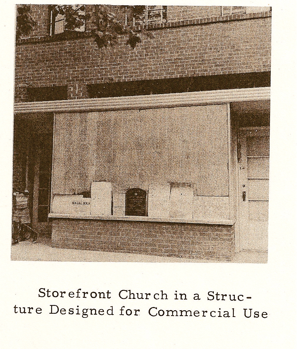
Before there was the Shaw School Urban Renewal Area there was NW pt 2
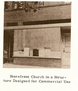
So I have sworn I've seen this storefront church window before, I just can't remember where. Driving me nuts now.
Anyway, where did I leave off? 1957. Italians.
Next is your favorite and mine, Shiloh Baptist church at 9th & P, then led by Rev. Earl L. Harrison who lived at 1743 Webster St NW, which I believe is in the Crestwood neighborhood. It had a membership of 7200 people, 1,200-1,500 attending worship services any given Sunday, with 3% living in the urban renewal area and 95% elsewhere in DC. There are no stats regarding occupational makeup. In 1957 they had a scouting program made up of participants from the church and the surrounding community, and a Baptist Training Union. It was founded in 1863 at 17th and L Streets and moved to its current location in 1924.
Bible Way Church of Out Lord Jesus Christ is not in Shaw but I find it very interesting. It is one the other side of NY Ave at 1130 New Jersey Ave NW. Their pastor, Rev. Smallwood E. Williams lived at 1328 Montello Ave NE. They had a total membership of 2000 people, and the average attendance exceeded the membership with 2200 (3,200 for all three services), it seems they had a lot of visitors and I gather a lot of non-tithers. Thirty percent lived in the renewal area and 69% scattered throughout the rest of rest of DC. This was a working class church, and that's why I find it so interesting as 90% of the working people attending were 'unskilled manual', with 2% professional, 3% white collar, and another 3% skilled manual labor. They had no mortgage and seemed to have owned a good chunk of land down there.
Last in my review is a church that was a storefront that is now a steeple church and that is Mt. Sinai Baptist Church at 1615 3rd St NW, then led then by Rev. Charles Hayes of 47 M St. NW. It had a membership of 225 people with an average worship service attendance of 125. A insignificant number of members, two percent, lived in the renewal area, 96% were in the rest of DC. Occupationally it was 55% unskilled manual, 40% white collar, and 2% professional. They had a mortgage of $2K. Listed under "Future Expansion Program" they desired to build a new church on the present site. If it became necessary to move (because of the renewal) they wanted to stay in this central area so it would be accessible to all members.
SUMMARY
Shaw had a lot of churches then, has a lot of churches now. There were Italians running around the TC on Sunday. And Marie doesn't like to spend a lot of time typing.
Labels: neighborhood history
Before there was the Shaw School Urban Renewal Area there was NW
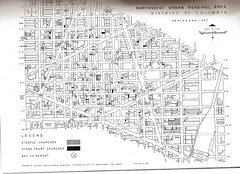
This should be at the DC Archives over on Naylor Court, NW because this comes from the DC RLA. And the 'this' is a church survey for a previous urban renewal idea of doing a nice big chunk in NW. The best I can tell of what happened with the NW Urban Renewal Area is that it shrank to the NoMa area, and at some point the Shaw School Urban Renewal came to be. Seriously, I'm fuzzy when it comes to all the various urban renewal programs that RLA, with the federal government (NCPC), churned out. There were several, a downtown, possibly a NE, Adams-Morgan, the famous SW, this NW one and Shaw.
Anyway, the little numbered circles in the shown map here of the NW urban renewal area are of the various steeple and storefront churches in 1957. I'm not going to list them all as there are several pages and I don't want to. But there are a few churches I want to highlight.
Steeple:
#3 Greater New Bethel; #4 Metropolitan; #10 Redeemer Italian Baptist; #13- Shiloh Baptist and #14 Bible Way Church of Our Lord Jesus Christ
Storefront Church:
#17 Mt. Sinai Baptist
The survey is basic, with name and address of pastor, ethnic make up, staff, and a few things about the membership I found interesting.
Greater New Bethel, then at 1739 9th St, had a membership of 700, with an average attendance of 350, parking for 25 cars, and 80% of the working members held white collar jobs. None of the members lived in the NW urban renewal area but all lived in DC.
Metropolitan Baptist at 1225 R St had a membership of 3,260, average attendance at the worship service was 1500. Of the working membership 25% were white collar, 30% unskilled manual, 15% skilled and 10% in business. Geographically 40% lived in the urban renewal area, 57% in the rest of DC and 3% in VA. In 1957 it had no mortgage.
Redeemer Italian Baptist, or 'ok I guess there was a strong eye-talian presence here'. It was at 1200 Kirby St and composed of white Italians. None of them lived in the urban renewal area, 40% were in the rest of DC and 60 % in MD & VA. The membership 125 with 60 showing up for worship services. A majority, 55% were skilled manual laborers, 30% white collar, and 10% in business.
Okay, I'm tired of typing, I'll pick this up again later.
Labels: churches, neighborhood history
House history in the most unlikely places
Okay the disclaimers:
Disclaimer #1- There are people out there who do house history for a living, I'm not one of them. If you're doing research on your house, I'm not the best resource, so please don't expect much if you ask a question.
Disclaimer #2- There are some reflections I make regarding archival theory that I just have zero interest in explaining to the layperson. In the end this is a personal blog, so if you find some things disturbing, express it elsewhere.
/end disclaimers
Doing random search for my house and my neighbors' houses, just to get a sense of the neighborhood, see if anyone else is blogging or what have you, I came across something quite interesting. It seems that a
notable person, not exactly in your middle school history book notable, but notable enough to have a place accept her papers, owned my house. Quickly, I need to state that Dr. Euphemia Lofton Haynes, the 1st Black woman to receive a Phd in Mathematics never ever lived in my house. Never. Ever. She might have looked at it from time to time. My house, as well as several other Shaw, Bloomingdale, and general DC houses were in her investment portfolio, which are included in her personal papers, which wound up at Catholic University, which decided at some point to put up the
finding aid on the web, which made it possible for me to stumble upon.
Now as someone who has processed personal papers for a university, I wondered if this would be the kind of stuff I'd keep. Because the items that I was looking at fall outside of the topic that makes Dr. Lofton-Haynes's papers valuable to the institution holding them, makes the accessioning archivist in me wonder. However, areas of income, income production and other aspects that allow the subject to engage in activities because of the freedom that extra money can bring, thus making these off topic files valuable. Yet, this would be the last place I'd even think of looking to find out about my house and neighborhood.
Just glancing over her real estate holdings, and almost all the files about particular houses have sales contracts showing the price she bought and later sold the property for, she did pretty well. Some files have correspondence and bills/invoices about repairs and improvement, which may not reflect all the money she poured into a place, but if those were the big major repairs, she made a decent buck on the sale. She bought a cluster of four houses Truxton Circle for $22,000 in 1945, and sold three of them individually for $8,000 in 1949; $9,500 and $12,000 in 1950. The sales contract also mention how much the houses are to be or were renting for, and the 1940s rents hovered between $40 and $45 dollars a month.
Besides sales contracts, there are title insurance papers, bills, loan receipts, correspondence about repairs, and very mundane things. Of course one property did have a notice from the DC Board of Condemnation of Insanitary Buildings informing Dr. Haynes-Lofton that her property had saggy floors, defective plumbing and electrical, broken door parts and ill fitting windows. Was the good Professor a slum lord? Don't know, some of the houses she sold the buyers had intended to live in them, so she couldn't have been that bad. She did upgrade some of the houses, installing gas in the kitchens, replacing roofs, and making repairs.
What I found most interesting was a non-Shaw property that involved her in a legal case with the federal government. One file labeled "Rental property, 1523 M st., lawsuit, speak easy, legal document, 1931" has letters and legal docs about a place she leased/rented that the Feds busted as a speak easy. She, through her lawyer, stated that she knew nothing about the activities of what was going on there. Considering the number of holdings she had all over the city and her professional activities in DC education, it is completely possible she did not know that she had a gin joint in her investment portfolio.
Labels: houses, neighborhood history
Sample of Shaw, 1880-1920
G-d Bless doctoral dissertations, gives people something to do, something to write and sometimes, it is of interest to people outside of academia.
The dissertation that may be of interest to y'all is "Changing Race, Changing Place: Racial, occupational, and residential patterns in Shaw, Washington, DC, 1880-1920" by Karl John Byrand, Doctor of Philosophy, Univ of Maryland, Department of Geography. Byrand does what I'm planning/ trying to do, but on a smaller scale. I didn't photocopy all the pages ('cause that would violate copyright and I didn't have enough cash to copy all I needed anyway), but he looks at the 1300 block of T, 1200 blk of 13th and the 900 blk of R, and if he looked at other blocks I don't know. What I do know is that it was a small sample and he was mainly interested in alleys, and alley dwellers.
The abstract of this reads as such:
During the late 19th and early 20th centuries, increasing black migration from the South changed the social structure of border cities such as Washington, DC. Prior to 1880, many of the District's black residents were confined to mini-ghettos within alleys; however, around the turn of the century, specific sections of the city underwent the process of racial concentration, forming large, predominantly black enclaves. Shaw, a neighborhood in northwest Washington, DC, was one of these areas.
The summary of this paper, just in case you never make it over to Hornbake Library, where this sits is:
The study area's overall population had grown by 18.5 percent since 1910, as compared to the 32.2 percent increase by 24 percent, as compared to the District's 16 percent growth between 1910 and 1920..... The data show increasing residential clustering based on skin tone, and perhaps ethnicity, over the previous periods with whites clustering together even more than previously, with more packing onto fewer blocks, perhaps in reaction to the other blocks becoming black/ mulatto dominated. Moreover, the rate of address sharing by white household heads had progressively increased from 12.7 percent in 1880 to 41.2 percent; now, a greater proportion of whites shared single residences than did blacks or mulattoes.... By 1920, Shaw had become the black business, entertainment, and residential community in Washington, DC. It would remain a lively center for black activity until after the Second World War, when many of Shaw's middle-class black residents would seek housing further from the city's core. After that, businesses and other services in the neighborhood would decline.
Labels: neighborhood history
1889 B/W
I'm finally getting to figuring out where am I with the census research. But it is going to take second place to getting around to writing an article for work. Anyway, cleaning out some of the files I found something I labeled "'State Censuses' District of Columbia'" and the title page reads "Index to the EXECUTIVE DOCUMENTS of the House of Representatives for the ..." 2nd session of the 15th congress, 1888-'89.
On page 206-207 lists the different blocks and their White/Colored make-up. Just doing the Northern TC and NJ Ave TC Adjacent portions, this is how it breaks down:
Block White Colored
507 157/ 111
508 81/ 0
509 216/ 41
509E 103/ 253
510 306/ 337
511 323/ 173
512 232/ 711
519 11/ 2
520 23/ 124
521 43/ 155
550 98/ 22
551 218(248)/ 417
553 129/ 488
553W 51/ 93
614 47/ 1
615 105/ 104
616 171/ 239
Labels: neighborhood history, Truxton Circle
Slummy history: 1944
In my occasion search to find the earliest time the neighborhood was started to be called by it's school border's name, Shaw, I find stuff. So in the March 11, 1944 issue of the Washington Post, an article titled "Alley Dwellers in Slum Areas Sordid, Senate Group Hears." It begins, "sordid conditions in the slum area in the heart of Washington-- streets on which it was decent women feared for their safety and 'real men' avoided to escape prostitutes..." The Thomas C.R. Gray the then president of the East Central Civic Association, which claimed its borders as 3rd St NE, FL Ave, 7th St NW, and Mass Ave, testified to the deplorable housing conditions of alley houses with no heat, no indoor plumbing, no bathtubs, no electricity, and infested with vermin.
Along with poor housing, there was crime. Prostitutes on Pierce St, in Glicks Alley & on Fenton Ct, and some sort of dangerous condition (not really stated clearly in the article) along the east side of 7th St between L & O Sts.
Labels: crime, neighborhood history
Lunchbreak history: The Big Bear
I'm calling this lunchbreak history as this is something I can churn out on my lunchbreak. Anyway, somewhere on the
Big Bear site, which has now disappeared (as the right hand column, with the history, was not there when I went there last) was a history of the Big Bear Cafe, which was the Big Bear Market, and that sort of was the history. So that inspired me to wander down to the library in the building and check out the city directories.
1919 was the first year I grabbed. The index by street is available in earlier years, but I can't remember how early. Anyway, in 1919 at 1700 1st there was a man by the name of Earnest D. Thorne, and he was a grocer.
Second book, was 1930 and the next guy at 1700 1st NW was Oscar Bernard Diskin. He was also a grocer. I looked for a Big Bear Market, but none was listed.
The last book I grabbed because well, lunch is nearly over, was 1967. At 1700 1st Street NW was the Fairway Market Grocers, telephone number DU7-7969. I did see a listing for a Big Bear Market in 1967, listed at 1018 North Capitol owned by Jack Mehlman. Well Big Bear Cafe, sounds way more interesting than Fairway Cafe, so I'm glad it eventually became the Bear. I wonder if Big Bear Market moved to 1st Street or if it is just a coincidence? The directories go up to 1970something. However, lunch over, back to work.
Labels: business, neighborhood history
A new day, now get to work
Lot of stuff I wanna cover ... It is September and InShaw has entered semi-retirement, or an active retirement. It may be another way of saying I'll post when I darned well feel like it, and post what moves me to post. So there may be several days when there is nothing, and periods of furious posting.
I've also changed the name slightly. So "(now with more gentrification)" has been dropped, in favor of what interests me, history. Gentrification still is in there but isn't the focus. The mad real estate boom has passed and the gentrification it fueled, has calmed a bit. If that rooming house, crack house, liquor store, vacant building hasn't been developed yet, it may be a while before it does. Maybe during the next wave of real estate fervor, maybe between now and then, and maybe never. In the meantime, there are other things to look at, like the past.
The past couple of years, the past couple of decades, whenever. I'm going with what a co-worker defined as history, anything that happened in the past. So anything between the Big Bang/Let-there-be-light and last week is up for grabs. But to be more DC focused I'll start somewhere in the 18th Century.
Today I just want to talk about Sunday's Washington Post.
Sorta under the title of 'gentrification' is
Income Soaring in Egghead Capital. Where I see the DC metro area is where the nation's well off African-American households live. Yet $55,547 is a pitiful amount compared to our Asian ($83,908) and Non-Hispanic White (94,290) colleagues. The data the Post provided kinda proved a belief that I had about the black middle class, they wanna get as far away from "Pookie" as their middle and upper-middle class white colleagues do. The highest median Black incomes $92,492 in Loudoun and $89,096 in Stafford, are far from the District ($34,484 and the highest percentage of population living below the poverty line).
Looking at my own middle class Black family, I and my blind great-aunt are the only ones in the District. The next closest relative tried to escape inner Beltway Prince George's County because of all that's going on around, but couldn't due to a failure to sell the house. If the house did sell, outer-waaay past Upper Marlborough would have been the new address. Then everyone else is in Fairfax Co. and Howard Co. I've noticed when the relatives move up in house, they seem to move further out. They express a desire for more space, more amenities (planned communities w/ clubhouse) and less crap.
But back to gentrification.... So if high earning African-Americans are engaging in black flight from the city and inner-ring suburbs, that could mean that they are leaving a residential void. A void filled by poorer Blacks and middle-upper class non-Blacks. Add to that the great big gap in incomes ($91,631-white; $67,137-Asian; $43,484-Hispanic and $34,484-Black), housing prices, and you got a problem. And I wonder, even if District employers provide the higher paying job opportunities, what is there to say that African-Americans who fill those positions will be from the District or will stay in the District? Okay, now I'm rambling, next...
Back from Behind Bars has a graph, that shows Truxton Circle as one of the communities where 5.1 or more (per 1,000 residents) ex-cons return to after being released from the criminal justice system. The other parts of Shaw (except what looks like upper U Street) have a rate of 5 or less per 1,000. The articles goes in on how those released have trouble finding housing and employment, and staying away from the things that led to prison.
And something that has more of a history bent an
opinion piece about Dunbar High School in its hey-day. It's more about integration and
colorism than the school itself, but the print version has a nice photograph of the school in 1931. The original school is no longer and it has been replaced by that prison-like building that dominates the TC skyline.
Labels: blog, gentrification, neighborhood history