Neighborhood Research
 It all began with my house. My house. The one they told me was built in 1900. Liars. I went to the MLK Library's Washingtoniana section up on the 3rd floor looking at building permits. I could not find a permit for my house. I guess no one bothered, or if they did it was lost to time. So I had to find another way of figuring out the age of my house.
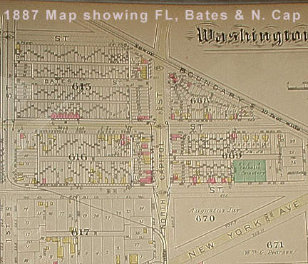
The library has a resource guide (PDF file). Now I had already looked at the permits so I looked at the Baist, Sanborn and Hopkins real estate maps. Maps helped(see above). However they only go back to 1887. My house was on it so, well at least a brick house shaped like my house. So, my house existed in 1887, being 13 years older than I thought.
At some point, and now I have forgotten the true inspiration, I decided I'd try my hand at a neighborhood history. I'd look at the demographic changes of Truxton Circle from 1930 to as far back as I can go and see what happened. I bit off more than I could chew. I never got a real feel for how F'ing big the project would be. At some point it dawned on me that Truxton Circle had over 1000 houses, for each census year, with lots of people in each of the houses. That's a lot of work. So now I'm just doing 1880, when (I believe) the census started recording the street addresses and I am going block by block to make sure I have done everything.
If you wanna know about your Truxton Circle house you can e-mail me or comment in this post and give me the property square number and I'll try to give you the enumeration district. In the above photo you can see that the property square number for P, O, North Cap & 1st street is Square 616. With the enumeration district number you can look for your house on microfilm at the MLK. Or you can all wait till I'm done collecting my research.
Labels: houses, neighborhood history, Truxton Circle
posted by Mari @ 16.1.05
![]()
![]()


0 Comments:
Post a Comment
Links to this post:
Create a Link
<< Home