1889 B/W
I'm finally getting to figuring out where am I with the census research. But it is going to take second place to getting around to writing an article for work. Anyway, cleaning out some of the files I found something I labeled "'State Censuses' District of Columbia'" and the title page reads "Index to the EXECUTIVE DOCUMENTS of the House of Representatives for the ..." 2nd session of the 15th congress, 1888-'89.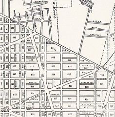
On page 206-207 lists the different blocks and their White/Colored make-up. Just doing the Northern TC and NJ Ave TC Adjacent portions, this is how it breaks down:
Block White Colored
507 157/ 111
508 81/ 0
509 216/ 41
509E 103/ 253
510 306/ 337
511 323/ 173
512 232/ 711
519 11/ 2
520 23/ 124
521 43/ 155
550 98/ 22
551 218(248)/ 417
553 129/ 488
553W 51/ 93
614 47/ 1
615 105/ 104
616 171/ 239
Labels: neighborhood history, Truxton Circle
posted by Mari @ 23.9.07
![]()
![]()


3 Comments:
what happen to TC? the only circle on that map is Cooper Circle unless my eye sight has totally failed.
The map doesn't show the Truxton Circle as it wasn't there in the 19th Century. Off the top of my head I think it was installed in the aughts of the 20th century.
could you please include square 514 in all future searches? :-)
thanks in advance!
Post a Comment
Links to this post:
Create a Link
<< Home